Saturday, January 8, 2011

RICHARD TOBIN, b. 1849, d. 31 Mar 1927

Richard Tobin is my maternal great-great-grandfather.  Little is known about him, where he comes from in Ireland, and who his parents and siblings were.  This blog is meant to document what I learn during my journey of getting to know him better.

Photo taken in 1924 on the Tobin Ranch in Birdseye, Montana.  Granddaughters Betty and Avis Ann "Sanny" Tobin are pictured with him - daughters of Richard D. Tobin, Sr. and Blanche Hannah Sites. A special thank you to Justine Tobin for this photo.
What I have learned thus far is credited to a family story written by Avis Ann "Sanny" Tobin, granddaughter of Richard Tobin, Valleys of the Prickly Pear 1888-1988, published by The Little Red Schoolhouse, Inc., Helena, Montana, 1988 (see additional information on each child's page). I have taken the liberty to add additional text in the form of notes, additional research, and my own comments. Thank you again to the descendents of the Richard D. Tobin Sr. family and the John L. Tobin family for assisting with photographs and documentation; and a special thank you to Justine Eidt Tobin for the sourcing of the original information and being the keeper of priceless family photos.

Richard Tobin's story starts when he was born October 1848 or 1849 in County Cork, Ireland (no known documentation other than death certificate indicating birth in Ireland in October 1849).  Timing of his birth coincides around the time of the "Great Famine in Ireland."

Richard came to America as a young man, and journeyed to Philadelphia, PA.  Shortly after he arrived in the United States, he wrote and asked Mary to join him.  They were married in Philadelphia.

Assumption Blessed Mary Virgin (BMV) Church, Philadelphia, PA
  
Richard went to work for James J. Hill's railroad, soon to be named the Great Northern, as a section foreman.  Several of his children were born while he was working for the railroad as the rails were laid westward (see pages for each child).  The family journeyed as far west as Drummond, MT while he was working working for the railroad and decided that it would be best for the family to settle.  In 1891, they purchased the property at Birdseye, MT (8 miles from Helena, MT on Seven Mile Creek near the Austin turnoff) and he built the family home (see page for Tobin Ranch).

A photo take by Karylyn Bliss, August 2009, a railroad siding near Fort Harrison and less than a mile from the Tobin ranch house is named after the Tobin family.
The Tobin ranch included a long, log house where the ten Tobin children were raised.  Richard's favorite expression was always "the first one gets the best shoes." 


Tobin Ranch [photo taken by Karylyn Bliss 17 Jan 2011]

The Tobin boys would often take the spur railroad to Marysville to a dance on Saturday night and get home in time to do the milking in the morning.


Richard Tobin [closeup]


Left to right: Richard Tobin, Ella (Tobin) Murray, "Sis" Tobin, Grandma ?, Alex Murray, Mary Tobin, Mary Tobin, "Mugs" Tobin, "Bud" Tobin, John Tobin. A special thank you to Justine Tobin for this photo.


One of the favorite stories the older grandchildren loved to hear Richard tell about in his deep Irish accent, was about Chief Rocky Boy of the landless Chippewa Cree Indians.  Chief Rocky Boy would bring his tribe of forgotten indians and camp across the road from the ranch for the summer.  There was a great deal of concern that they would camp there for the winter, and the family would have to worry about feeding the tribe.  To encourage them to move on, the family would give the Chief a steer and suggest they move on.  One Spring, the tribe returned with ponies for the Tobin boys, and Richard told them, "No, my boys are wild enough without riding Indian ponies." 

Historically, the Chippewa lived in bands on both sides of the Canadian border and the Great Lakes region. The Tribes began their migrations in the 1700s and 1800s and by the early 1890s had united in a search for a permanent home - a place where children could be brought up in peace, where native religion would be uninterrupted and flourish. In 1916, Rocky Boy's Reservation was established by Executive Order and is located near Havre, Montana, approximately 200 miles north of Birdseye, Montana. The leaders and their people, numbering 450 at the time, had sought refuge in sizable Montana towns, cities, and even other Montana Indian reservations including the Blackfeet, Flathead, and Fort Belknap Reservations. [Reference http://www.rockyboy.org/]

In 1904, a man by the name of Ike LaVelle was causing havoc by dynamiting the trains and robbing them.  His hideout was close to Birdseye, and when the County Sheriff found out about it, he and his crew came out to capture him.  The Tobin boys wanted to help, but Richard wouldn't let them because they were too young.  LaVelle was eventually captured at Birdseye and taken to jail in town.  When the jailer was taking him to the Courthouse, he escaped by killing his captor.  The jailer he killed was the grandfather of Bill Korizek and Helen Kovich from Helena, MT.  It was an incident that all the children never forgot. 

Richard Tobin [closeup]


Left to right: "Hector", Ella Tobin Murray, Richard Tobin, ? [circa 1920s, unknown location].  A special thanks to Justine Tobin for this photo.


Richard Tobin [circa 1920s, unknown location].  A special thanks to Justine Tobin for this photo.


Richard Tobin [circa 1920s, unknown location].  A special thank you to Justine Tobin for this photo.

Richard and Mary continued to live on the ranch after the children were married. 

Note:  John L. (his son), and his wife "Mugs" and two children "Sis" and "Bud" lived on the ranch also.  Both "Sis" and "Bud" were born on the ranch.  A special thanks to Jeff Tobin for this information.

Also, Richard D. (his son), took his father, Richard, on a train to Barnes Hospital in St. Louis for tongue cancer surgery [verbal story told to Richard's great-grandson, David Tobin, from his father Richard Donald Tobin Jr.]. A special thanks to Justine Tobin for this information.


Richard died at the age of 78 on March 31, 1927 at St. John's Hospital in Helena, MT.  Richard's death certificate lists the principal cause of death as tongue cancer (onset 1 year).  Internment is at Resurrection Cemetery, Helena, Lewis and Clark, Montana.

Document in the possession of Benda Neuenswander.

Helena Independent Record dated 31 Mar 1927: "Richard Tobin, Sr., for many years a prominent resident of this county, died late last night at a local hospital after a long period of failing health.  Mr. Tobin was 79 years of age, a native of Ireland.  He is survived by his widow and four sons, Richard, Jr., John and Frank Tobin, of Helena, and William Tobin, of Lewistown, and four daughters, Mrs. E. Murray, of Great Falls; Mrs. R. J. Dilley, of Payette, Idaho; Mrs. Frank Farley, of San Francisco, and Miss Mary Tobin, of Helena.  Arrangements for the funeral were not complete last night.  Mr. Tobin's body is at Opp and Conrad's funeral home."

Photo taken by Karylyn Bliss, August 2009, near the Tobin railroad siding, looking south towards Helena, MT


RESEARCH NOTES
Passenger Lists:  I am currently searching ship passenger lists, microfilms, etc. at the Family History Library (Salt Lake City, UT), and have yet to locate him.

Great Northern Railroad:  see additional blog "Great Northern Railroad."

Marriage:
It is my belief that Richard Tobin married Mary Rickerts in Philadelphia, PA.  The date and location of their marriage coincides with the family story written by Avis Ann "Sanny" Tobin even though Mary's last name is different.  I also believe Mary's last name is Rickerts based on several of the older children's marriage certficates list their mother as Mary Rickerts or Ricketts.  Also, the christening certificates of Patrick Tobin and Mary Tobin state their mother's name is Ricketts or Richards.  More confusion comes with documents from later children as to their mother's maiden name. 

Therefore, for the purposes of this blog, I am assuming Richard's wife's name is Mary Rickerts, as seen on the following documents.  Of note, I located these documents via a records search at the LDS Church Genealogy Library [microfilm # is written at the bottom of these documents].  They are entries into a log by the person performing the ceremony for the city of Philadelphia.  Noteworthy:  After two years of searching marriages for a Richard Tobin around 1880 in all of the United States, this is the only hit I had:


On 8 Jan 2011, I met with Benda Neuenswander [my mother's sister].  I did not tell her about my search for the last two years for the marriage of Richard Tobin.  She unknowingly produced the following document, which by the way, coincides with the two log entries listed above.


U.S. Federal Census:
Unable to locate Richard Tobin earlier than 1910

1910 ~ Butler School District, Lewis and Clark County, MT (16 Apr 1910)
    Tobin, Richard, head, male, 51, b. Ireland, parents=Ireland, immigrated=46, farmer
    Tobin, Mary, wife, female, 30, b. Ireland, parents=Ireland, immigrated=36, house
    Tobin, Richard D, son, male, 23, single, b. Dakota, parents=Ireland, conductor, railroad
    Tobin, John, son, male 21, single, b. Montana, parents=Ireland, laborer
    Tobin, Joe, son, male 13, single, b. Montana, parents=Ireland, house
    Tobin, Frank, son, male, 11, single, b. Montana, parents=Ireland, house
    Tobin, Mary, daughter, female, 23 single, b. Dakota, parents=Ireland, house
    Tobin, Johanna, daughter, female, 8, single, b. Montana, parents=Ireland, house

1920 ~ Clough School District 32, Lewis and Clark County, MT (9 January 1920)
    Tobin, Richard, head, male, 68, immigrated 1862, naturalized 1904, b. Ireland, parents=Ireland, farmer
    Tobin, Mary, wife, female, 62, immigrated 1864, naturalized 1904, b. Ireland, parents=Ireland, housewife
    Tobin, Joe, son, male, 23, single, b. Montana, parents=Ireland, farming
    Tobin, Frank, son, male, 21, single, b. Montana, parents=Ireland, farmer
    Tobin, Mary, daughter, female, 31, single, b. North Dakota, parents=Ireland, housekeeper
    Tobin, Ella, daughter, female, 26, single, b. Montana, parents=Ireland, school teacher


"Declaration of Intention" #1601 to be come a U.S. Citizen, dated 28 Oct 1902. District Court of the First Judicial District of the State of Montana.


Death Certificate - State of Montana


Resurrection Cemetery, Helena, MT [St. Matthew Section, third section south from center mausoleum near the middle of the cemetery. Two large pine trees are located to the right of these markers, not pictured. Top left is Mary Tobin (b. 1882).  Top right is Joseph Tobin (b. 1896).  Bottom left is Richard Tobin (b. 1849.  Bottom right is Mary Tobin (b. 1855).  Photos taken Karylyn Bliss, August 2009.


Information obtained by my brother Kevin Butt on 17 Jan 2011 at Retz Funeral Home, Helena, MT.  Of note, Retz bought out Opp and Conrad and had this information on Richard's death.

~ LEWIS AND CLARK COUNTY CLERK/RECORDER ~
Records Search 18 Jan 2011:  My brother, Kevin Butt, and I spent the morning at the county clerk's office looking through volumes of old land records.  Kevin starting with looking up GRANTORS books  from 21 April 1865 through 4 Jan 1916 searching for any Tobins selling land.  These books are hand written logs listed with alphabetical tabs for the last name for the GRANTEE and consecutively by date with the earliest day listed first under each alphabetical tab.

The first Tobin name that came up was for a Michael P. Tobin [unknown if related] selling land on 26 May 1909.  Also, the first known Tobin relative record was dated 10 Nov 1916 where John & Margaret Tobin were selling a mining claim "Blue Cloud Placer Mine."  I located several documents where the children of Richard and Mary Tobin were purchasing land or homesteading land [see pages for each child for additional land information]. 

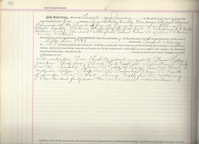
I started looking at GRANTEES books starting with March 1865 through 7 Nov 1923 searching for Tobins purchasing land.  The first record I located was for Michael P. Tobin [unknown if related] purchasing land dated 12 Feb 1894.  I then found a record with Richard Tobin along three others (James B. O'Neill, William Tunley, and Rheinold Dahlberg) dated 2 Jan 1902 purchasing together a quick claim deed for 1/3 interest in a mine located on147 acres of land. [see document below].

I then searched the PATENTS book (AKA homsteading claims which normally includes 160 acre parcels).  I started with the first book and entry for Lewis and Clark County dated in the year 1862.  I looked through every entry through 1894 and could not locate a patent for any Tobins through 1894.  This means that Richard Tobin did not homestead and the land he lived on.  Family lore states he "purchased" the property in 1892; however I could not locate a document proving this in either the GRANTORS or GRANTEES books. 

I asked the county clerk about not being able to locate a document of Richard Tobin purchasing the land and she suggested I look through the GRANTORS books again, looking at all the railroads in Lewis & Clark County.  NOTE:  Kevin looked up how many railroads were in Montana in the late 1800s coinciding with the time land was purchased and learned there are, well too many to count [see http://en.wikipedia.org/wiki/List_of_Montana_railroads].  Searching will require multiple GRANTORS names and tons of time to perform this.  So I have decided to put this question of proving when the original land was purchased on the back burner for now.   Noteworthy:  Kevin also looked up the Northern Pacific Railway as a GRANTOR and looked at all the entries for Tobins listed as GRANTEES and did not find anything.


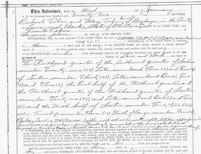
The next entry I found in the GRANTORS book for Richard Tobin was where Richard and Mary Tobin were deeded property owned by Joseph Tobin after his death in 1921 [see notes on Joseph Tobin].  Richard and Mary deeded this property to their son, Frank Tobin on 3 Jan 1922 totalling 734.53 acres [see document below].


Thursday, January 6, 2011

Valleys of the Prickly Pear 1888-1988

The following photos are taken from of a book published by The Little Red Schoolhouse, Inc., Helena, MT, 1988, contributing author Avis Ann "Sanny" Tobin, daughter of Richard D. Tobin, Sr.  A special thanks to Justine Eidt Tobin for the sourcing of this document and photographs.


1896-Cascade County, Montana

CASCADE COUNTY DIRECTORY AND GAZETTEER 1896-1897
Ridgley and Greeley Compilers and Publishers
http://www.montanagenweb.com/gazette.html

GREAT FALLS
In 1882, the present site of Great Falls, the Cataract City, was simply a stretch of prairie, upon which grazed hundreds of buffalo and antelope. Along the banks of the Missouri, now alive with the hum of industry, Indians and adventurous hunters made their camps. Save the ceaseless plunge of the old Missouri’s waters over its’ rapids and falls, there was nothing to indicate the upbuilding of a great manufacturing and commercial center.

In that year, 1882, a visit was made to this place by Paris Gibson, who perceived the immense possibilities of the situation. A number of other gentlemen were interested, and in 1884 the original townsite of Great Falls was platted. In 1887 the the town had grown to a population of 500, and in that year the Great Northern reached the town and gave it an impetus which sent it straight on toward the proportions of a city.

Its’ growth from that time has been steady, substantial and progressive. Capital was attracted by the magnificent possibilities of profitable investment offered, and labor followed closely in its’ wake.

Business blocks, equal to any in older and larger cities, were erected and comfortable and commodious homes followed as the residence portion was built up. Manufacturing industries of various kinds were located, and proved lucrative investments. The great water power of the Black Eagle Falls attracted the Boston & Montana Smelting Company, and they moved their plant here from Butte. Other industrial enterprises followed the example, and the near future will see the banks of the Missouri at Great Falls the seat of an industrial community as busy as are those on the banks of the Merrimac and its’ tributaries.

While the recent panic brought with it doubt and distrust, and called a halt to the growth and expansion of the city, it was a pause only, and already the Cataract City is regaining its’ old-time gait, which will eventually make it the metropolis of the Northwest.

Outside of the indomitable energy of its’ citizens, the secret of Great Falls’ prosperity and the guarantee of its future greatness is found in the great water power furnished by the Missouri at this point. The importance of this factor is fully brought out in a recent article by M.S. Parker, C.E., from which the following extracts are taken:

“Among the large water powers of this country, the falls of the Missouri river in Cascade County, Montana, unquestionably rank second only to the falls of Niagara. The full development of this great power would, naturally, under other conditions, be slower of development than that of Niagara.

“The falls of the Missouri proper are a series of cascades and rapids extending over a distance of 16 miles, from the crossing of the river by the Great Northern railway bridge at the head to the mouth of Belt Creek. The principle cascades, in the order in which they occur, are called Black Eagle, Rainbow, Crooked and the Great falls, names given to them by the early explorers, Lewis and Clarke. Between these falls, and below the last named, are series of smaller cascades and rapids capable of development into what would be considered large powers in section of this country less favored by nature with respect to water power.

With a population of 11,269, Great Falls is in every respect a first-class, up-to-date, progressive city, with all the conveniences which that implies; in fact, her equipment in that respect puts many an older and larger rival to blush. Situated in the center of a great mining, agricultural and grazing country, she has a magnificent future before her.

DIRECTORY AND GAZETTEER of Cascade County Excluding Great Falls

ARMINGTON
Armington is situated in the Belt valley, 23 miles east of Great Falls, on the Neihart Branch of the Montana Central and the Great Falls & Lewistown Mail and Stage Line. It is the receiving and shipping point for merchandise of wool, cattle, sheep and horses for Geyser, Stanford, Utica, Philbrook, Lewistown, Gilt Edge and the Judith Basin Country. The resources are coal, produce of all kinds, cattle, hogs, sheep and horses.

BELT
This busy mining camp is situated on the Neihart branch of the Montana Central railroad, about 26 miles from Great Falls. It is the seat of extensive coal mining operations and has had a marvelous growth since 1894. Before that time, in 1877, J.K. Castner had prospected successfully for coal and he and Michael Worley began mining operations in that year, shipping the product to Fort Benton. In 1889, work was stopped on the mine on account of the high freight rates charged by the railroad company who controlled the mines at Sand Coulee. In 1893, the property passed into the hands of the Anaconda Mining company.

Belt was first called Pittsburg in honor of Mr. Castner’s Pennsylvania home, but this was afterward changed to the present name. Belt is a live hustling town and has a prosperous future in store, and is well supplied with the conveniences of civilization.  There are several churches, a bank, large stores and a weekly paper.

CASCADE
Cascade is situated on the north bank of the Missouri river on the Great Northern R.R., opposite the beautiful Chestnut valley noted for its’ beautiful homes and its’ fine ranches, which are stocked with fine thoroughbred horses and cattle. Sheep raising is one of the leading industries in this immediate vicinity. Within a radius of 35 miles, there are about 250,000 sheep, 75,000 head of cattle and 50,000 head of horses. The town of Cascade proper has about 100 inhabitants, but two years ago there were more than 200 persons
registered at this point. The school facilities are of the best and are under the able supervision of Prof. Geo. H. Mullery. There are two churches, two blacksmith shops, two hotels and one livery stable.

Mr. Thomas Graham was the founder of the town which has grown to be one of the most thriving in Cascade county. At present a ditch is being constructed in the Chestnut valley which will be capable of carrying 25,000 inches of water and which will, when completed, make the Chestnut valley the garden spot of Montana. Streams adjacent to Cascade are stocked with mountain trout in great numbers. Close to Cascade there are large “sloughs” where geese and ducks gather in great numbers in the fall of the year, making a perfect paradise for the hunter.  Mr. Robt. Chestnut, who settled more than 30 years ago in the valley which bears his name, is still an honored resident.

CORA
Cora is situated about 28 miles east of Great Falls, on the Montana stage line , and is the center of a prosperous community of stock growers. Sheep raising takes the lead, and there are 50,000 head of sheep within a radius of 10 miles from Cora.

EVANS
Evans is a country village, consisting of not more than half a dozen houses, and a post office, about 28 miles south of Great Falls. It is situated at the head of main Sand Coulee, and is usually called Upper Sand Coulee. It was settled about the year 1879 by Messrs. Jamison, Johnson, Fowler and Tague, the two latter gentlemen having come from the Upper Missouri valley. Evans is in Precinct No. 13 and School District No. 14. There are about 150 voters in the precinct, and about 40 school children in the district, with three schools, No. 1, 2, and 3. Miss Maud Warner is teacher in the primary department; Miss Olive Brown in the
intermediate, and Miss Steff in the fifth and sixth grades. The school directors are: James Collard, chairman; Mrs. Wm. Warner and Geo. Gillet. Argiculture is the main industry of Evans, it being known throughout that part of Cascade county as the “Garden of Montana”. Sand Coulee creek furnishes a bountiful supply of splendid water for all purposes, and crops have never been known to fail. William Warner is the postmaster.

GEYSER
Geyser is situated about 47 miles from Great Falls , and is 23 miles from Armington, the shipping point on the Neihart branch of the Montana Central. There is considerable farming carried on in the vicinity, but stock-raising is theprinciple industry. Mail arrives on the stage daily, and there is telephone connection with the principal places in the state.

HARDY
Hardy is a station on the Montana Central, 47 miles from Great Falls. Grazing and agri-culture are the leading occupations. Hardy is also the distributing point for the upper Chestnut valley.

HEPLER
Hepler is a post office six miles above Fort Shaw and is a stage connection with Sun River. The surrounding country is devoted to stock raising and agriculture.

KIBBEY
Kibbey is a post office on Otter creek, about 43 miles southwest of Great Falls and 9 Northeast of Monarch. It is the center of a very fine country, which is being rapidly developed. The Montana Stucco Works are located here, and the gypsum mines are of a very high grade.

LOGGING CREEK
Logging Creek is located on the Niehart branch of the Montana Central, at the mouth of Logging creek and is noted for the fine quality of lime rock for making lime and fluxing and the excellent fir timber in the immediate vicinity, which is driven down Logging Creek. The place is also noted for trout fishing, the trout being very plentiful in both Logging and Belt Creeks. Gold placer mines extend for 10 miles up Logging creek. The quartz mines of the carbonate district are very rich in silver and gold and claim the largest lead of copper in the state.

MID - CANYON
Mid-Canyon is a farm post office on the Montana Central about 45 miles southwest of Great Falls, in the center of a fine farming and small fruit country. Mr. James Wantz, one of the first settlers, has been particularly successful in the introduction and culture of the small fruits, as well as tomatoes and melons, marketing seven tons of tomatoes from 4,000 plants.

MILLIGAN
Milligan is the center of a very fine stock-raising country, about 47 miles south of Great Falls. The town is situated on Trout creek, and receives mail semi-weekly.

MONARCH
Monarch is a beautiful canyon town on the banks of Belt creek, at the junction of the Barker and Neihart branches of the Montana Central railway, surrounded by the rich agricultural districts of Kibbey, Belt, Park, and the Michigan settlements, which are renowned for fertility of soil and the abundance of rich pasturage for stock-raising purposes. This is the distributing point for supplies of hay, grain and all the cereals for the mining camps of Sand Coulee, Belt, Armington, Neihart and Barker, from, the outlying agricultural districts, this being their nearest shipping point. The coal camps of Sand Coulee, Belt and Armington have for years past received all their mining timber from this point, and the demand for poles and cordwood for the Great Falls smelters has been amply supplied from this place.

The railroad ships a large amount of cordwood each year for it’s own use from Monarch, making it a noted timber center. Monarch is also noted for being a natural summer resort, furnishing the finest fishing in Montana. Belt Creek is well supplied with trout and whitefish, and the streams of Dry Fork, Tillinghast, Pilgrim, and Tenderfoot are literally full of trout and greyling. These streams being quite near Monarch, make it one of the pleasantest resorts of Montana, and it is much patronized by tourists. The surrounding mountains for a distance of 20 miles abound with all the kinds of game for which Montana is justly noted. The altitude is 4.553 feet sea level. The population is about 100.

RICEVILLE
Riceville is a signal station on the Neihart branch of the MontanaCentral, 38 miles from Great Falls. An important industry is the preparation of flux for the smelters.

SAND COULEE
Sand Coulee is an unincorporated mining camp of 2000 inhabitants, 12 miles southeast of Great Falls, and is the terminus of the Sand Coulee branch of the Great Northern Railroad company, the Great Northern Express company and the Western Union Telegraph company. It was first settled in 1888 as a mining camp, but Eugene Willis, a colored man located the first coal claim in 1883. Sand Coulee has three churches - Methodist Episcopal, Slavonian Roman Catholic and Finnish Lutheran; three libraries - English, Scandinavian and Finnish; the English library contains 1,200 volumes and is supported by the employees of the coal company, formed into an association; a good public school with four teachers; a bank, three hotels, one restaurant, one general store; one furnishing house; a brickyard one mile north of town, and several small coal mines for local and country trade; two brass bands, one orchestra; several secret societies; one labor organization, known as the Western Federation of Miners (Inc.); two livery stables; one laundry; and an opera house with a seating capacity of 300, and also a gymnasium in connection. Sand Coulee is represented by one newspaper, the Belt Valley Times, printed at Belt , Montana, every Thursday. B. Jeremiah is correspondent for the Times. T.A. Gillespie is postmaster.

ST PETER’S
St. Peter’s is a post office and mission in the northwestern part of the county, 35 miles from Great Falls, and has stage connections from Cascade. The surrounding country is Devoted to agriculture and grazing. Extensive Indian schools are carried on by the Jesuit Fathers and Ursuline Nums.

SUNNYSIDE
Sunnyside is situated 13 miles west of Great Fall, with daily stage connections. Several large ranches are in the immediate vicinity.

SUN RIVER
Sun River is situated 20 miles west of Great Falls and is the center of some of the best farming land in Northern Montana. The land is under high cultivation and irrigation is extensively used. Mining is also carried on. There is a daily stage from Great Falls.

TRULY
Truly is situated 13 miles southwest of Great Falls, and is the center of an agricultural community. Cattle and sheep raising are extensively carried on. There are also excellent coal deposits in the vicinity.